Saturday, January 27, 2007

Faction Map 05 (click on map to enlarge)


The above map of the Empire shows the political alignment of each province as of Oron 15, Salgan 1, Adonsik 41 Cledman VI while armed conflict is raging during the Emperor's incapacitating illness between troops loyal to two competing claimants to the title of "Imperial Regent". An imperial regent is someone who rules on behalf of the emperor while the emperor is unable to rule. The two claimants to the title are Lord Chancellor Rubanya Cledman and Imperial Councillor Levorek Cledman. Both of them are also potential heirs to the throne.

In provinces where the Ulor and the military are not on the same side, the map is marked according to the loyalty of the military.

Orange = Provinces controlled by Rubanya (22 provinces)
Purple = Provinces controlled by Levorek and Krulmuk (20 provinces)
Blue = Provinces controlled by Regionalists (9 provinces)
Gray = Neutral provinces (28 provinces)
Red = Separatist/Rebel contrlled provinces (2 provinces)


Faction forums are here:
http://naegame.proboards83.com/


Please note that the two leaders claiming to be the Imperial Regent are also the leaders of the two main factions that had previously existed. Rubanya was the leader of the Reformist Faction and Levorek was the leader of the Loyalist Faction. Whoever could gain the power of Imperial Regent would almost certainly claim the throne when the emperor dies. Because Rubanya and Levorek have radically different ideas about how the Empire should be run, it would make a huge difference to the people which side wins. At the time of this map, the emperor was very sick and expected to die any day.

Faction Map 04 (click on map to enlarge)


The above map of the Empire shows the political alignment of each provincial government as of Oron 23, Salgan 10, Adonsik 40 Vylor Cledman VI.


Orange = Reformist (21 provinces)
Purple = Loyalist (18 provinces)
Blue = Regionalist (8 provinces)
Gray = Neutral (32 provinces)
Red = Separatist/Rebel (2 provinces)


Faction forums are here:
http://naegame.proboards83.com/


Please note that the leaders of the Loyalist and Reformist factions, Levorek Cledman and Rubanya Cledman, are both potential heirs to the throne. If the Emperor died, these same factions might battle each other for the succession to the throne. Because they have radically different ideas about how the Empire should be run, it would make a huge difference to the people which side wins.

Faction Map 03 (click on map to enlarge)


The above map of the Empire shows the political alignment of each provincial government as of Oron 18, Salgan 10, Adonsik 40 Vylor Cledman VI.


Orange = Reformist (13 provinces)
Purple = Loyalist (18 provinces)
Blue = Regionalist (3 provinces)
Gray = Neutral (45 provinces)
Red = Separatist/Rebel (2 provinces)


Faction forums are here:
http://naegame.proboards83.com/


Please note that the leaders of the Loyalist and Reformist factions, Levorek Cledman and Rubanya Cledman, are both potential heirs to the throne. If the Emperor died, these same factions might battle each other for the succession to the throne. Because they have radically different ideas about how the Empire should be run, it would make a huge difference to the people which side wins.


For more information on the factions and their leaders, please read the article on the Stavuk Vyloresh (Imperial Council) here.

Friday, January 26, 2007

Faction Map 02 (click on map to enlarge)


The above map of the Empire shows the political alignment of each provincial government as of Oron 1, Salgan 9, Adonsik 40 Vylor Cledman VI.


Orange = Reformist (15 provinces)
Purple = Loyalist (19 provinces)
Gray = Neutral (47 provinces)
Yellow = Separatist( 0 provinces)
Red = Rebellion ( 0 provinces)

Faction forums are here:
http://naegame.proboards83.com/


Please note that the leaders of the Loyalist and Reformist factions, Levorek Cledman and Rubanya Cledman, are both potential heirs to the throne. If the Emperor died, these same factions might battle each other for the succession to the throne. Because they have radically different ideas about how the Empire should be run, it would make a huge difference to the people which side wins.

For more information on the factions and their leaders, please read the article on the Stavuk Vyloresh (Imperial Council) here.

Thursday, January 25, 2007

Faction Map 01 (click on map to enlarge)


The above map of the Empire shows the political alignment of each provincial government as of Oron 1, Salgan 7, Adonsik 40 Vylor Cledman VI.


Orange = Reformist (13 provinces)
Purple = Loyalist (21 provinces)
Gray = Neutral (46 provinces)
Yellow = Separatist( 0 provinces)
Red = Province is in rebellion (1 province, Kopixer Province, #52)

Faction forums are here:
http://naegame.proboards83.com/


Please note that the leaders of the Loyalist and Reformist factions, Levorek Cledman and Rubanya Cledman, are both potential heirs to the throne. If the Emperor died, these same factions might battle each other for the succession to the throne. Because they have radically different ideas about how the Empire should be run, it would make a huge difference to the people which side wins.

For more information on the factions and their leaders, please read the article on the Stavuk Vyloresh (Imperial Council) here.

Region Map (click on map to enlarge)


This is a map of the regions of the Zekresh Empire
(click on map to enlarge)

Region forums are here:
http://naegame.proboards83.com/


Regions are administrative units created by the imperial government which include a number of provinces. These regions have been slowly evolving into another level of government.

The Imperial decree issued by Emperor Cledman III which created the regions did not intend to create "regional governments". Provincial governments were intended to remain entirely autonomous from the regions. Regions exist because some parts of the central Imperial government have regional offices. The Imperial Postal Service, the Imperial Tax Service, the Imperial Army, the Imperial Navy and the Imperial Spy Service all maintain regional offices. Prior to Emperor Cledman III's decree, each of these organizations defined the regions differently. Now, they all use the same regions as can be seen on the region map. The Imperial government, always on guard against separatist threats, has been very careful to keep the regions virtually powerless and without central leadership. For example, Imperial Army units are only under the authority of the regional headquarters for administrative purposes such as promotions and supplies. Operational command of army units is in the hands of provincial commanders and the main Imperial Army command at Zekran. The regional generals do not have the authority to order army troops to move or fight. This is supposed to be true in the navy as well, but since naval units are stationed at naval bases which don't exist in most provinces, most of the ships are at the main regional navy bases. The regional admirals do not have operational command of the fleets in their regions, but the fleet commanders who do have such authority are all congregated at the regional navy bases.

Although the regions have no legal authority over any provincial Ulor, during the reign of Emperor Cledman VI, the Overseas Region created a new innovation. Because the Overseas Provinces were relatively new and there were no good roads connecting them, the provincial governments formed a "roads council" for the Overseas Region to coordinate road construction and maintenance. In recent years, this has been copied by all the other regions even though the need in the older regions is only for road maintenance. Each roads council includes the Ulor of every province in the region. Recently, roads councils have become a forum for discussion of cooperation between provincial governments on a wide variety of issues, not just roads. More than one Ulor has suggested changing the name from "roads council" to "regional council" and electing a chairman who would run a more powerful regional government. This idea has stalled because of fear of an adverse reaction from the Emperor.

Zekresh Empire Map 08


(click on map to enlarge)

Here are a few words in Zekresh that appear on the map:

kast = fort
serat = city
bakoy = port
shasa = river
blib = lake
lish = sea
nass = bay
karak = mountain range
aluvad = one mountain
tros = North
trosesh = Northern
iluva = South
iluvesh = Southern
yost = East
yostesh = Eastern
folon = West
folonesh = Western
Glivo Trayakir = Gateway Waters
dinak = white
grif = blue
shan = grey
fligera = bat
grond = stone
olond = bone
yvar = haven

Salan Kast Vyloresh

CLICK ON IMAGE TO ENLARGE


This is Kast Vyloresh province and some of Falanalish province.

Green areas are wilderness beyond the borders of the Empire. Yostan is not shown, but it is one of the "Eastern Settlements" whose location is labelled "Kromosteko Yostesh" (which means "Eastern Settlements" in Zekresh.

Yostan

CLICK ON IMAGE TO ENLARGE


This is a map of the "Kromosteko Yostesh" (Eastern Settlements) in Kast Vyloresh province in the Overseas Region. The location of Yostan and the other settlements are marked.

Proposed Aatanian Provinces

(Click on Map to Enlarge)

Province Map and Info (click on map to enlarge)


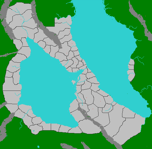
On the province map above:

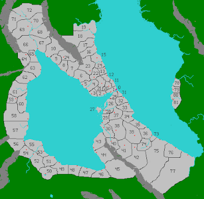
On the map above, each province is identified with a number. The table below provides the names of the provinces. Some or all of the province names are links to closeup maps and more information on each province.

..........Actual...........Province..................Origin of
..........Province.......Name........................Province
#........Name.............in English................Name
...................................................................
0........Zekran...........Zekran.....................Named for Zekryva who founded the
...................................................................city.

1........Frayethay ........Frayeth Land.......Named for Frayeth people who fled
...................................................................there from South Peninsula.

2........Slythia...............Viper Land...........Named for a tribe of wildmen.

3.......Nass Mysktia.....Hidden Bay........Named in Zekresh for a geographic
....................................................................feature.

4.......Kajakan Yost.....East Bear Land....Named in Zekresh for the Verron .....................................................................(bear) tribe of wildmen. Their .....................................................................territory became three
.....................................................................provinces.

5.......Kajakan Folon...West Bear Land...Named in Zekresh for the Verron
......................................................................(bear) tribe of wildmen. Their ......................................................................territory became three
......................................................................provinces.

6.......Kajakan Tros.....North Bear Land...Named in Zekresh for the Verron
......................................................................(bear) tribe of wildmen. Their ......................................................................territory became three
......................................................................provinces.

7.......Ferillyan..............Smoke Land..........Named for a tribe of wildmen.

8....Iluvan Shasif....Crying Moon Land...Named for a tribe of wildmen.

9.....Vumman...........Hummingbird Land...Named for a tribe of wildmen.

10.....Kaliskan............Stag Land................Named for a tribe of wildmen.

11.....Yormukan ..........Yormuk's Land......Named for Yormuk, a Zekresh
......................................................................warlord who conquered the
......................................................................wildmen there.

12.....Flitran..............Crab Land.................Named for a tribe of wildmen.

13.....Lastilan.............Fog Land.................Named for a tribe of wildmen.

14.....Shasan...............River Land..............Named in Zekresh for a tribe of
......................................................................wildmen.

15.....Yusha Fonan........Blue Jay Land.....Named for a tribe of wildmen.

16...Vinrat Troslot....Old North Frontier...At one time it was the frontier
.......................................................................of the Empire.

17..Vinrat Trosazh...New North Frontier..At one time it was the frontier
........................................................................of the Empire.

18.....Zurithani...............Wildman...............Named this in Zekresh when it
.......................................................................was beyond the Imperial frontier.

19.....Zurian................. Wilderness............Named this in Zekresh when it
.......................................................................was beyond the Imperial frontier.

20.....Kast.....................Fortress.................Named in Zekresh for the fortress of
......................................................................Kast Yvar.

21.....Uvinshakh Voint....Interior Peninsula.....Named because of its
...............................................................................geographic location.

22.....Tanan...................Otter Land............Named for a tribe of wildmen.

23.....Otlor..................Turtle Land.............Named for a tribe of wildmen.

24.....Vipathan...............Spider Land.........Named for a tribe of wildmen.

25.....Logoria................Cliff Land..............Named for a tribe of wildmen.

26.....Grogia..................Frog Land.............Named in Gavrinian for a tribe of
......................................................................wildmen.

27.....Lisal Koppa.........Clam Island..........Named for a tribe of wildmen.

28.....Groglinth...............Frogside.............Named in Gavrinian for an old
......................................................................settlement alongside the Frog River

29.....Ilania......................Ilania...................Named for the semi-mythical Prince
......................................................................Ilan.

30.....Ravelonia...........Ravelonia............. Named for Ravelon, the God of
.....................................................................Magic.

31.....Sishan...........Tide Land...................Named for a tribe of wildmen

32...Kikalan Tros....North Fire Land........Named for a tribe of wildmen, their
......................................................................territory became two provinces

33...Kikalan Inuva..South Fire Land........Named for a tribe of wildmen, their
......................................................................territory became two provinces

34.....Yenthitia...........Starfish Land..........Named for a tribe of wildmen

35.....Pilania................Green Land.............Named for a tribe of wildmen

36.....Lankar Tioka...Boat People Land....Named for a tribe of wildmen

37.....Corinweld...........Ravenwood...........Named in Gavrinian for a tribe of
......................................................................wildmen.

38.....Warnan.................Lion Land............Named for a tribe of wildmen

39.....Dronan..................Oak Land.............Named for a tribe of wildmen

40.....Ulawan...............Cloud Land............Named for a tribe of wildmen

41.....Lokotra.................Owl Land..............Named for a tribe of wildmen

42.....Fanezrit...........Sand Snake Land......Named for a tribe of wildmen

43.....Varlan..................Fox Land................Named for a tribe of wildmen

44.....Nyarlan..............Dog Land................Named for a tribe of wildmen

45.....Barylan...........Jackal Land................Named for a tribe of wildmen

46.....Ovam................Savannah.................Named in Zekresh because most of
......................................................................the land is dry Savannah land, the
......................................................................first such land the Zekresh settled.

47.....Ovam Vyex......Far Savannah............Named in Zekresh because most of
.......................................................................the land is dry Savannah land, the
.......................................................................second such land the Zekresh
.......................................................................settled.

48.....Vindaroyen......Nomad People..........Named for a tribe of wildmen

49.....Upinthen...........Rabbit Land.............Named for a tribe of wildmen

50.....Blib Showatan....Lake Showatan......Named after the large lake in the
........................................................................province. Showatan means "large"
........................................................................in the language of the local
........................................................................wildmen.

51.....Frangees...........Frangees...................Named for a tribe of wildmen. The
.......................................................................origin of their name is obscure.

52....Kopixer...........Scorpion Land.................Named for a tribe of wildmen

53.....Sligifteria...........Claymaker Land......Named for a tribe of wildmen

54...Tlom Yerula.....Stone People Land.....Named for a tribe of wildmen

55.....Zamarula......Magic People Land......Named for a tribe of wildmen

56...Vibika Ashak...Desert People Land...Named for a tribe of wildmen

57.....Jikerola...........Bat People Land.........Named for a tribe of wildmen

58..Grigna Zarula...Lizard People Land.....Named for a tribe of wildmen

59.....Uvinan...........Hinterland....................Named in Zekresh for its geographic
.......................................................................location relative to the Far Coast
.......................................................................settlement

60.....Olalga Vyex...........Far Coast.............Named in Zekresh for its geographic
.......................................................................location relative to Zekran.

61.....Silway Siliken......Fisher People Land....Named for a tribe of wildmen

62.....Esan...........Mouse Land....................Named for a tribe of wildmen
.......................................................................(slightly corrupted and with Zekresh
....................................................................... suffix)

63...Lolensturn...Round House People....Named for a tribe of wildmen (but the
.......................................................................name is corrupted and abbreviated)

64.....Thalaning...........Deep Forest...........Named for a tribe of wildmen

65.....Nassavix..............Bayside.................Named in Zekresh for its geographic
.......................................................................location

66.....Baaniferan...........Moose Land.........Named for a tribe of wildmen

67.....Trayavix...........Crossroad.................Named in Zekresh after the main city
.......................................................................which is at the crossroads of the
.......................................................................coast road and the river road.

68.....Shasa Falan...........Upriver................Named in Zekresh for its geographic
.......................................................................location

69.....Foerfen...........Wolf Land..................Named for a tribe of wildmen

70....Glantogran......Red Hand Land.........Named for a tribe of wildmen

71.....Aatan.......Mountain Goat Land.......Named for a tribe of wildmen

72.....Helmarie...........Headwaters...............Named in Trondan because two
.......................................................................major rivers originate here.

73.Lilash Huvenia.....River Monster Land...Named for a tribe of wildmen

74.....Ptaria.............Sparrow Land...............Named for a tribe of wildmen

75..Vinrat Inuvesh Lot....Old Southern Frontier.......At one time it was the
.........................................................................................frontier of the Empire

76...Kromostekan Azh.......New Settlement........Named for the Zekresh
.................................................................................settlement there.

77..Vinrat Inuvesh Azh....New Southern Frontier....It is the frontier of the
.........................................................................................Empire.

78.....Azh Zekran.........New Zekran.............Named after the Imperial Capital
.........................................................................City of Zekran

79.....Sarnyvan.........Sarnyva's Land..........Named after Sarnyva who led the
........................................................................expedition which founded the
........................................................................settlement.

80.....Falanalish...........O'er the Sea.............Named because of its geographic
........................................................................location.

81.....Kast Vyloresh...........Imperial Fort.....Named because it is the location of
.........................................................................the main Imperial fort and garrison
.........................................................................in the Overseas provinces.

Second Map (click on map to enlarge)


Second Map
(Zekresh Empire)

On the second map:

On the second map, the Imperial Capital City of Zekran is shown as a purple dot with a boundary around it marking the territory associated with it that is not considered part of any province. The Imperial City of Zekran is located at the northeastern end of the straits connecting the Eastern Sea with the Western Sea. Also on the second map, provincial capitals are marked with small red dots.

The small red dot outside the empire is an active volcano and this is the usual meaning of red dots on maps in Nations and Empires. However, there are no active volcanos in the Zekresh Empire so you can be sure that any red dot within the boundaries of the Empire marks the capital city of a province.


On all maps:

Dark grey masses indicate mountain ranges.

Light blue indicates water and can be lakes, rivers or seas depending on size and shape.

On some maps that have not yet been revealed, dark blue indicates deeper ocean waters.

Light grey marks lands that are part of the Zekresh Empire.

Black lines mark the borders of provinces and nations.

Green indicates lands that are not under imperial control.

Green dots in the sea are islands that are not under imperial control. If they are near a coast controlled by the Empire, the islands are claimed by the Empire, but not under actual Imperial control.

Some mountain valleys are also green or partly green even though they are in the middle of the Empire. This is not a mistake. The green lands are not under imperial control. In the case of mountain valleys, this is generally because they are relatively inaccessible. After there is a player for every province, new players may take the part of leaders of independent enclaves in the green mountain valleys or islands or as the leaders of barbarian tribes beyond the imperial borders.

First Map (click on map to enlarge)


First Map
(The 81 Provinces of the Zekresh Empire)


On the first map:


On the first map, each province is identified with a big red square. Black lines mark province borders. Some province borders are not marked with black lines because an obvious natural obstacle forms the border such as a coastline, mountain range or river. Sometimes both sides of a river are part of the same province and in other cases, each side of the river is a separate province. The placement of the big red squares on the first map makes clear which rivers are province boundaries. If there is only one red square inside a set of borders, it is one province, regardless of whether a river runs through it. If there is a red square on each side of the river, it is two provinces. The red squares do not represent any feature on the land, they merely help clarify where all the provinces are. The Imperial City of Zekran is not marked on that map, but it is not considered a province or part of any province.

Small red dots are active volcanoes. They are often surrounded or partly surrounded with grey squares indicating mountainous terrain.


On all maps:

Dark grey masses indicate mountain ranges.

Light blue indicates water and can be lakes, rivers or seas depending on size and shape.

On some maps that have not yet been revealed, dark blue indicates deeper ocean waters.

Light grey marks lands that are part of the Zekresh Empire.

Black lines mark the borders of provinces and nations.

Green indicates lands that are not under imperial control.

Green dots in the sea are islands that are not under imperial control. If they are near a coast controlled by the Empire, the islands are claimed by the Empire, but not under actual Imperial control.

Some mountain valleys are also green or partly green even though they are in the middle of the Empire. This is not a mistake. The green lands are not under imperial control. In the case of mountain valleys, this is generally because they are relatively inaccessible. After there is a player for every province, new players may take the part of leaders of independent enclaves in the green mountain valleys or islands or as the leaders of barbarian tribes beyond the imperial borders.